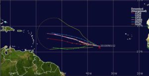
 Haiti Action.net – Port au Prince, Haiti — Tropical Storm GASTON was only given a 10% chance, yesterday, but has surprised the over-taxed forecasters at the National Hurricane Center in Miami (NHC) by its “vigorous” development overnight. Some of the global models used by the NHC “do not even acknowledge that the cyclone exists now or in the near future…” But the visible satellite images clearly show the early closed convection that belie the computer generated models and have the forecasters sharpening their neglected pencils and relying more on past experience.
GASTON has become the seventh named storm of the 2010 Atlantic Hurricane season and the fourth named storm of the last two weeks. The season had been relatively quiet through July and August.
As GASTON is primarily being steered by a large deep-layer subtropical ridge to the north that should keep it on its current westerly heading for the next four days, the interests in Haiti should be keeping a closer watch on this tropical cyclone than on the last three. GASTON is tracking closer and slower to the ITCZ and could make it the first major Hurricane to pass the Windward Islands into the Caribbean. If the storm tracks closer to the GFNI model, it’s development to a major hurricane is more likely.
Over the next few days, GASTON will be heading into significant vertical shear that could weaken the system and break up the closed convection. Further east, is yet another developing system that could become a tropical depression as soon as tomorrow, develop into Storm HERMINE and follow GASTON by about three days.
RAW
