
Bulletin météo du jour* L’environnement du bassin de la Caraïbe est sous l’influence de l’air humide et instable à cause de la circulation successive des Ondes Tropicales dans la région. A cet effet, des activités de pluie et d’orages peuvent affecter le pays tout au long de l’échéance du bulletin. *Prévision pour Haïti* Généralement ensoleillé au cours de la journée Forte sensation de chaleur en journée et en début de soirée ; Passages nuageux en fin d’après-midi ; Tmax comprise entre 31 à 36 degrés Celsius ; Tmin comprise entre 22 à 24 degrés Celsius ; Averses de pluie isolées prévues aujourd’hui sur les départements du Nord, du Nord-est, de l’Ouest, du Centre, de l’Artibonite, et du Sud-est. *Tendance pour les deux prochains jours*: Mardi & Mercredi: Pluie et orages éparses prévues avec le passage d’une Onde Tropicale.
Two Atlantic waves could develop toward the weekend (or beyond)
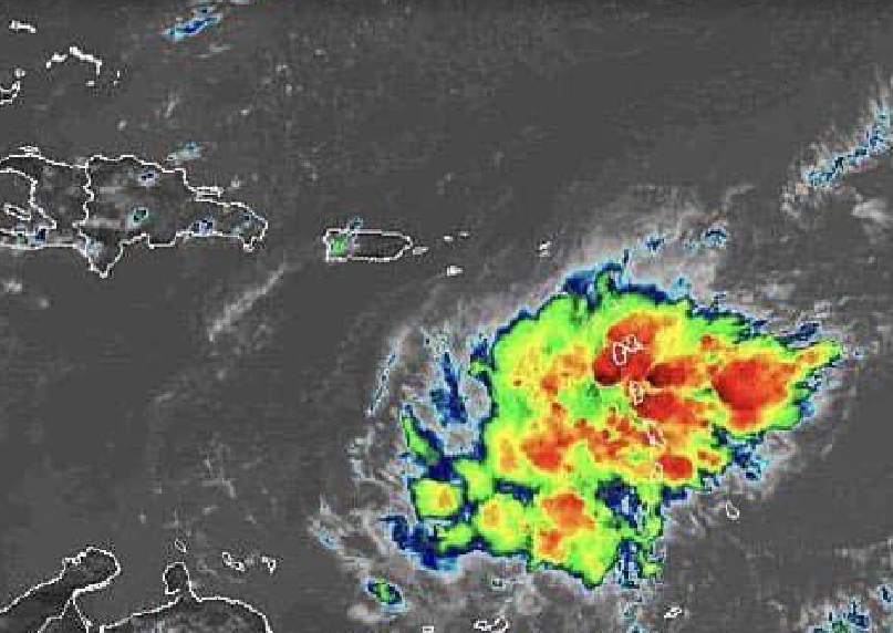
Heavy showers and thunderstorms have been peppering Puerto Rico and the Virgin Islands since Monday, the result of Invest 95L. This disturbance failed to close off a low-level center in the hostile conditions of the northeast Caribbean, but it remains a strong enough tropical wave to produce a broad shield of convection.
As it moves northwest atop the very warm waters of the Florida Straits and The Bahamas, 95L will get another chance to organize—but only a slim one, as moderate to strong wind shear and patches of relatively dry mid-level air will take their toll. Less than 10% of ensemble members from the 12Z Tuesday GFS and European model runs generate a tropical cyclone east of Florida with 95L. In its 8 pm EDT tropical weather discussion, NHC gave 95L just a 10% chance of developing into at least a depression between Thursday and Sunday. The wave could still bring showery, breezy conditions to The Bahamas and perhaps Florida’s east coast.
There’s a bit more potential for the next wave to develop. Located in the eastern tropical Atlantic on Tuesday, this disturbance will enter progressively more favorable conditions as it moves west-northwest. From the Tuesday morning model runs, about 30% of European ensemble members and a majority of GFS members show some development of this wave as it approaches the Leeward Islands in the 6- to 8-day time frame. A general northwestward track beyond that point is plausible, as suggested by the extended-range GFS and European operational runs, but the system’s fate by then would hinge on its exact track and strength, potential land interactions, and weather features that are too far ahead to pin down with any confidence.
In its 8 pm EDT tropical weather discussion, NHC gave this system a 40% chance of developing into at least a tropical depression east of the Lesser Antilles between Thursday and Sunday.