Two of three budding tropical systems in the Atlantic will approach the Caribbean, Central America and the United States in the coming days.
Three batches of thunderstorms are moving westward across the tropical Atlantic.
From west to east, the systems have been dubbed Tropical Storm Harvey and 92L. The third system is likely to be 93L.

This image shows the tropical Atlantic Ocean at 1 a.m. EDT, Friday, Aug. 18, 2017. Three swirls in the clouds from the middle to the right are a tropical wave (near Hispaniola), Tropical Storm Harvey (approaching the Windward Islands) and 92L. Ninety-three L was just entering the image to the lower right. (NOAA/satellite)
A designation is assigned between 90 and 99, when there is potential for the formation of a tropical depression or storm within several days. The “L” represents potential formation for the Atlantic Ocean.
Interests in the Caribbean and Central America should closely monitor the tropical Atlantic, particularly shipping, cruise and fishing ventures.
Tropical Storm Harvey to enter Caribbean Sea this weekend
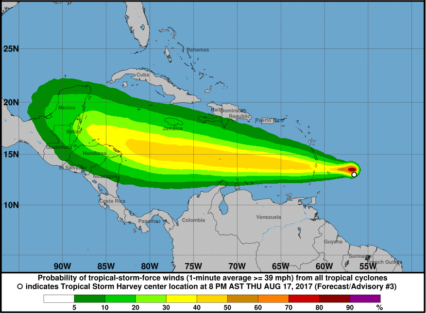
Tropical Storm Harvey developed on Thursday afternoon east of the Windward Islands, becoming the eighth named tropical system of the 2017 Atlantic season.
Heavy, gusty thunderstorms from Harvey will affect the Windward and southern Leeward Islands through Friday.

Enough rain can fall on the islands to cause flash flooding and mudslides. Wind gusts can be strong enough to cause minor property damage. Small craft should stay in port on Friday.
How much strengthening occurs will determine the intensity of rainfall, winds and seas.

Inhibitive strong winds aloft are diminishing in the path of Harvey, which may allow it to strengthen.
Harvey could become a strong tropical storm or hurricane in the coming days.
The most likely path of this system is westward across the Caribbean due to strong steering winds this weekend. Harvey may make landfall as a Category 1 hurricane in Central America on Monday night.
92L may pass north of the Caribbean Sea next week
Steering winds are likely to guide the second area of disturbed weather farther north than Harvey.
“We project 92L to pass over or just north of the Leeward Islands this weekend,” according to AccuWeather Hurricane Expert Dan Kottlowski.

Some dry air has become drawn into 92L, which could hinder its development for a time.
“If 92L can overcome the dry air, it has a chance at becoming a depression or tropical storm this weekend,” Kottlowski said.
A track just north of the islands of the northern Caribbean, especially the mountainous islands of Puerto Rico, Hispaniola and Cuba, would favor development and strengthening, as opposed to a track right over the islands.
In addition to the mountains and dry air, strong winds aloft may work against rapid development.
At this time, 92L represents the greatest potential of all of the systems for approaching the U.S. or its coastal waters next week.
Following a wave of non-related thunderstorms this weekend, an uptick in thunderstorms from 92L could reach the northwestern Bahamas and South Florida by Tuesday.
System closest to Africa may remain at sea
The system farthest to the east, and likely to become 93L, will take a west-northwest path the next few days.
“However, a turn toward the northwest is likely this weekend,” Kottlowski said.
“Ninety-three L may never be a threat to land in the western part of the Atlantic Basin,” Kottlowski said.
This system may become a tropical system this weekend and could strengthen significantly if it avoids dry air and strong westerly winds aloft next week.
Batch of thunderstorms to reach South Florida this weekend
An area of heavy thunderstorms that rolled through the British and United States Virgin Islands and Puerto Rico on Thursday will continue westward over Hispaniola, Cuba and the Bahamas into Saturday.

While this area of disturbed weather is unlikely to develop into a tropical depression, it will spread drenching thunderstorms into South Florida on Saturday.
Real Atlantic hurricane season is just beginning
Additional batches of thunderstorms will continue to roll westward from Africa in the coming weeks.
The next six to eight weeks represent the heart of the hurricane season.
As the peak of the hurricane season approaches, on Sept. 10, the likelihood of tropical storm and hurricane formation will increase due to warm water, shrinking dry air and diminishing winds.