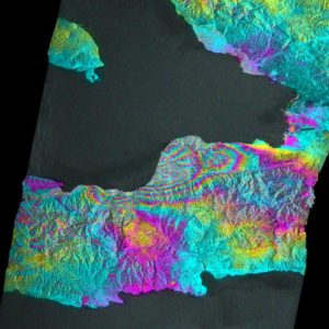
 Radar interferogram showing ground deformation from Haiti quake
Radar interferogram image from the Japan Aerospace Exploration Agency’s Advanced Land Observing Satellite Phased Array type L-band Synthetic Aperture Radar (ALOS PALSAR), showing ground deformation from the Haiti earthquake in the city of Léogâne, west of Port-au-Prince. The color “fringes” show contours of the ground deformation caused by the earthquake. Each contour represents 11.8 centimeters (4.6 inches) of ground motion. Léogâne moved upward about 0.5 meters (20 inches) in the earthquake. These data are similar to what NASA’s proposed Deformation, Ecosystem Structure and Dynamics of Ice (DESDynI) mission will collect in the future. Image credit: NASA/JPL/JAXA/METI