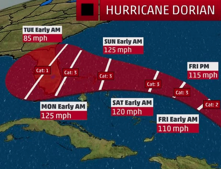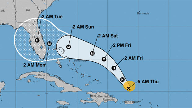
Hurricane Dorian was getting stronger as it set its sights on the U.S. mainland early Thursday, churning over open waters. “Strengthening is forecast during the next few days, and Dorian is expected to become a major hurricane on Friday,” the National Hurricane Center said.
Dorian became a Category 1 hurricanejust before making landfall on the U.S. Virgin Islands Wednesday, causing power outages and minor flooding. Puerto Rico avoided a direct hit, dodging a bullet.
The storm was on a path likely taking it to Florida’s Atlantic coast, though an arrival farther north wasn’t out of the question. It could make landfall on the U.S. mainland as a Category 3 storm late Sunday or Monday morning, forecasters said.
As of 5 a.m. EDT Thursday, Dorian’s center was some 150 miles north-northwest of San Juan, Puerto Rico, as it headed northwest at 13 mph, the hurricane center said. Dorian’s sustained winds increased to 85 mph, with higher gusts.
“Life-threatening flash floods” possible
The National Hurricane Center warned early Thursday that heavy rain from Dorian could cause “life-threatening flash floods” in parts of the Bahamas and southeastern U.S. coast.
The center forecast 2-4 inches of rain in some parts of the Bahamas, with six inches in isolated spots, and 4-8 inches with an upside of a foot in other areas of the Bahamas and coastal southeastern U.S.
CBS News weather producer David Parkinson pointed out that, “With a new supermoon and the angle the storm is approaching from, widespread coastal flooding, including severe coastal flooding is likely. In addition, as the storm is coming in for landfall, it looks like it might lose some of the steering currents,” slowing it down and resulting in even more rain.
Flooding and power outages in U.S. Virgin Islands
There were some reports of power outages and flooding in the U.S. Virgin Islands, British Virgin Islands and Puerto Rican islands of Vieques and Culebra, the Associated Press reported. But Culebra Mayor William Solís said only one community lost power Wednesday.
“We’re happy because there are no damages to report,” Solís told the AP.
U.S. Virgin Islands Governor Albert Bryan Jr. closed schools and government offices and issued a curfew from noon Wednesday until 6 a.m. Thursday morning. “This means that only emergency responders and those providing essential services would be permitted on the road at this time,” he said in a statement. “We ask for the public’s full cooperation during this time.”
South Florida residents begin gathering supplies
Miami resident Lanada Means said she purchased plywood at Home Depot on Wednesday to begin preparing for the storm. “My daughter messages me on Instagram and asked me if I knew about the storm, and I didn’t, so I came here on my lunch break. Tomorrow is gonna be crazy,” she told CBS Miami.
Carol Brafman said she is buying enough supplies for five family members. “They come to my house because I have a generator,” she told CBS Miami. “We’ve been through [Hurricane] Andrew and the last one we went north to Carolina. It’s not easy. None of us know.”
Florida governor declares state of emergency
Florida Governor Ron DeSantis has declared a state of emergency Wednesday. He encouraged residents to gather seven days of supplies, including water, food and medicine. The storm is expected to reach the Florida coast this weekend.
“I will continue to monitor Hurricane Dorian closely with emergency management officials. The state stands ready to support all counties along the coast as they prepare,” he said in a statement.
80-year-old man dies in Bayamón
Puerto Rican police said an 80-year-old man died in Bayamón on Wednesday as he made preparations ahead of the storm, the Associated Press reported. The victim fell from the roof of his home after attempting to clear debris off of it.
Dorian could strengthen into a major hurricane
Dorian has thrown forecasters a few curve balls over the past day, the biggest of which was a large shift to the east. While that is good news for Puerto Rico, it is a bad sign for the U.S. East Coast.
The reason the storm has shifted is because its circulation has been rather disorganized and big convective bursts (clusters of thunderstorms) on the east side of the circulation are making the system lopsided, pulling and tugging the center further east.
This means Dorian will avoid the beating it would have taken if the system had passed over the high mountains of Puerto Rico and the Dominican Republic. Instead, it will emerge north of the islands Wednesday night as a healthy storm system. That healthy system can then more easily intensify as it moves north.
Knowing this, the next question is: Will the system enter an environment favorable for intensification? Increasingly, the answer seems to be yes.
— Jeff Berardelli
Tropical Storm Erin weakens to a depression
A tropical depression off the southeast U.S. coast, dubbed Erin by forecasters, strengthened into a tropical storm early Wednesday before weakening back to a depression later in the day.
As of 11 a.m. EDT Wednesday, Erin’s center was approximately 470 miles west-northwest of Bermuda and 190 miles southeast of Cape Hatteras, North Carolina, the National Hurricane Center reported. The storm was moving north-northwest at 13 mph with maximum sustained winds of 35 mph. It’s expected to move north and northeast out over the open Atlantic.
