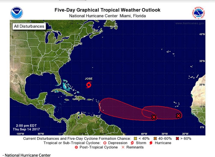
As Tropical Storm Jose threatened to bring life-threatening rip currents to the East Coast, the National Hurricane Center was watching two other disturbances in the eastern Atlantic Thursday evening (Sept. 14).
- A tropical wave about 850 miles west-southwest of the Cabo Verde Islands was producing disorganized cloudiness and showers. Conditions were expected to be favorable for gradual development of this system during the next several days, and a tropical depression will likely form early next week as it moves westward at about 15 mph across the tropical Atlantic. Tropical formation chances were 30 percent through 48 hours and 80 percent through five days.
- Showers and thunderstorms associated with an area of low pressure about 300 miles south of the Cabo Verde Islands continued to become better organized Thursday afternoon. Environmental conditions are expected to remain favorable for development, and a tropical depression is likely to form Thursday night or Friday. The system was forecast to move westward to west-northwestward at 10 to 15 mph across the eastern tropical Atlantic during the next couple of days. Formation chances were 80 percent through 48 hours and 90 percent through five days.
- At 4 p.m., Tropical Storm Jose was 515 miles south-southwest of Bermuda, moving west-northwest with at 8 mph. This motion was expected to continue through Friday, followed by a turn to the northwest on Saturday. Maximum sustained winds were 70 mph and some restrengthening was forecast to begin on Friday, and Jose was likely to become a hurricane again by the weekend. Forecasters warned Jose could cause life-threatening surf and rip current conditions along the U.S. coast.


