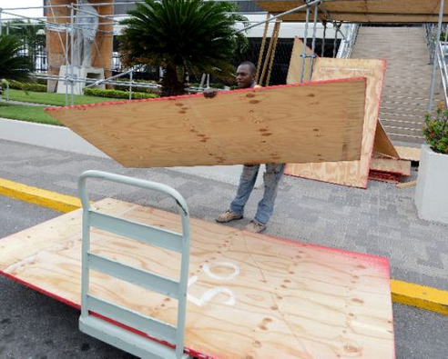
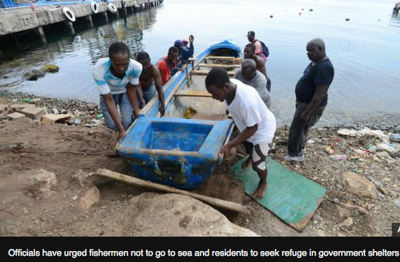
Haitian interim President Jocelerme Privert warned Haitians Sunday to make preparations for Hurricane Matthew, which no longer threatened just the southern peninsula, but all of Haiti.
The heavily deforested nation is not only at risk of mudslides, but also serious flooding that could lead to the loss of lives and damage to homes. There are also concerns about a spike in cholera, the waterborne disease that has killed more than 9,000 and sickened more than 700,000 Haitians since it was introduced to the country six years ago this month.
It’s not just cholera residents are concerned about. Next Sunday’s rerun presidential and legislative elections could also be affected by the storm. Privert said the elections remain as scheduled for Oct. 9. However, one official said they will decide if a postponement is necessary later in the week after they have a better idea about Matthew’s impact.
Preparation, Privert said in a national address, cannot wait. He called on those living in houses at risk of collapsing under rain and wind to seek refuge with family and friends, and for those living along the coast to evacuate.
Privert also announced that schools would close on Monday and Tuesday so that many of them can be used as shelters. Haiti suspended inter-departmental travel and public outdoor markets Sunday and the Interior Ministry announced late in the day that both international airports in Port-au-Prince and Cap-Haitien would be closed from 6 a.m. Monday to 6 a.m. Wednesday.
“My Haitian people,” Privert said, “don’t be stubborn, don’t think ‘God is Good’ [and will take care of you].”
“The message we are giving is important. You will have to evacuate all of the areas that represent a danger for you,” he said. “The life of every person is important to us.”
Since Saturday, workers in orange shirts from the Office of Civil Protection were mobilizing across the mountainous country, warning citizens of the pending storm. They also were trying to buy hurricane supplies.
Haitian officials said they did not get the same quantity of aid, including hurricane supplies, from foreign donors this year as in previous years. And while they “drastically reduced spending,” they remain strapped for cash to address damages if Matthew hits the country hard.
“We will not beg, but we will not refuse either,” Interior Minister Francois Anick Joseph told the Miami Herald.
Joseph said they had several tons of rice, which had previously been donated by Japan, that they plan to use if need be. There were also water and mattresses in stock. On Sunday morning, France had asked whether it could dispatch two surveillance airplanes into Haitian airspace to survey the southern coastlines. The government gave the O.K.
The U.S. Agency for International Development deployed two disaster response teams to Haiti and Jamaica Sunday to help coordinate relief efforts in the region.
“The biggest threat we have over our heads is water,” Joseph said. “When you hear hurricane, it means rain, it means wind, it means the sea rising.”
Joseph said there were 1,300 shelters available for the country that were able to host 340,000 people. He also clarified another statistic. He said there were 381 firefighters for the country — not 30 as someone said the previous day during a hurricane preparation meeting. He said there were 30 for Port-au-Prince.
“We are very concerned about the country’s vulnerability,” Joseph said. “We’ve redoubled our efforts to reduce the risk for the population.”
In all, he said, there were 18,196 government employees already deployed or ready to be deployed to help the population if the storm were to hit hard.
In Port-au-Prince, winds were beginning to pick up and it was drizzling on and off Sunday afternoon. Bulldozers could be seen in some parts of the capital, clearing streets of mountains of trash. Many canals, however, remained clogged with trash.
By 5 p.m. the rain had also started to pour in the southeastern coastal city of Jacmel.
Officials did not discuss money during the national address. But Joseph conceded that the cash-strapped country was working with very little and did not have the financial means that it had in years past. What it does have, he said, is manpower, which is being tapped throughout the country.
“We have no choice but to mobilize throughout the country,” he said. “I also believe that it’s an occasion for us to show our resilience, to show the capacity that we have in the face of adversity.”
Meanwhile, the U.S. Embassy in Haiti authorized family members of U.S. government employees to leave the country and recommended that U.S. citizens do the same. The embassy will be closed Monday and Tuesday.
In Petionville, a tiny suburb above Port-au-Prince, at least one gas station had already boarded up Sunday evening.
Dr. Jean Pierre Brisma, who was buying groceries at Big Star Supermarket in Petionville, said he is concerned about Matthew and the damage it could create.
“I don’t think the country is ready,” he said. Brisma said recent rains, which have triggered flooding in Petionville and elsewhere, show what a little bit of rain can do.
“If the government doesn’t stop people from building anywhere and how they want, we will always be vulnerable to hurricanes,” he said.


000
WTNT34 KNHC 040014 CCA
TCPAT4
BULLETIN
HURRICANE MATTHEW INTERMEDIATE ADVISORY NUMBER 23A…CORRECTED
NWS NATIONAL HURRICANE CENTER MIAMI FL AL142016
800 PM EDT MON OCT 03 2016
CORRECTED WATCHES AND WARNINGS SUMMARY AND MINIMUM PRESSURE
…HURRICANE HUNTERS FIND MATTHEW IS STILL A 140-MPH HURRICANE…
…LIFE-THREATENING RAIN…WIND…AND STORM SURGE EXPECTED IN
PARTS OF HAITI TONIGHT…
SUMMARY OF 800 PM EDT…0000 UTC…INFORMATION
———————————————-
LOCATION…16.6N 74.6W
ABOUT 120 MI…190 KM S OF TIBURON HAITI
ABOUT 200 MI…325 KM SW OF PORT AU PRINCE HAITI
MAXIMUM SUSTAINED WINDS…140 MPH…220 KM/H
PRESENT MOVEMENT…NNE OR 15 DEGREES AT 8 MPH…13 KM/H
MINIMUM CENTRAL PRESSURE…934 MB…27.58 INCHES
WATCHES AND WARNINGS
——————–
CHANGES WITH THIS ADVISORY:
None.
SUMMARY OF WATCHES AND WARNINGS IN EFFECT:
A Hurricane Warning is in effect for…
* Haiti
* Cuban provinces of Guantanamo, Santiago de Cuba, Holguin, Granma,
and Las Tunas
* Southeastern Bahamas, including the Inaguas, Mayaguana, Acklins,
Crooked Island, Long Cay, and Ragged Island
* Central Bahamas, including Long Island, Exuma, Rum Cay, San
Salvador, and Cat Island
A Hurricane Watch is in effect for…
* Cuban province of Camaguey
* Turks and Caicos Islands
* Northwestern Bahamas, including the Abacos, Andros Island, Berry
Islands, Bimini, Eleuthera, Grand Bahama Island, and New Providence
A Tropical Storm Warning is in effect for…
* Dominican Republic from Barahona westward to the border with Haiti
* Jamaica
A Tropical Storm Watch is in effect for…
* Dominican Republic from Puerto Plata westward to the border with
Haiti
Interests elsewhere in Hispaniola, the Bahamas, and in the Florida
Peninsula and the Florida Keys should monitor the progress of
Matthew.
A Hurricane Warning means that hurricane conditions are expected
somewhere within the warning area. A warning is typically issued
36 hours before the anticipated first occurrence of tropical-storm-
force winds, conditions that make outside preparations difficult or
dangerous. Preparations to protect life and property should be
rushed to completion.
A Hurricane Watch means that hurricane conditions are possible
within the watch area. A watch is typically issued 48 hours
before the anticipated first occurrence of tropical-storm-force
winds, conditions that make outside preparations difficult or
dangerous.
For storm information specific to your area, please monitor
products issued by your national meteorological service.
DISCUSSION AND 48-HOUR OUTLOOK
——————————
At 800 PM EDT (0000 UTC), the eye of Hurricane Matthew was located
near latitude 16.6 North, longitude 74.6 West. Matthew is moving
toward the north-northeast near 8 mph (13 km/h). A turn back toward
the north at a faster forward speed is expected later tonight
through Tuesday night. A turn toward the north-northwest is forecast
on Wednesday. On the forecast track, the center of Matthew will
approach southwestern Haiti tonight, move near eastern Cuba late
Tuesday, and move near or over portions of the southeastern and
central Bahamas Tuesday night and Wednesday.
Maximum sustained winds remain near 140 mph (220 km/h) with higher
gusts. Matthew is a dangerous category 4 hurricane on the Saffir-
Simpson Hurricane Wind Scale. Some fluctuations in intensity are
possible during the next couple of days, but Matthew is expected to
remain a powerful hurricane through Wednesday.
Hurricane-force winds extend outward up to 40 miles (65 km) from
the center and tropical-storm-force winds extend outward up to 185
miles (295 km).
The minimum central pressure recently reported by an Air Force
Reserve reconnaissance aircraft was 934 mb (27.58 inches).
HAZARDS AFFECTING LAND
———————-
WIND: Hurricane conditions are expected to first reach Haiti
tonight, eastern Cuba Tuesday, the southeastern Bahamas late
Tuesday, and the central Bahamas on Wednesday. Tropical storm
conditions are expected to continue spreading across Haiti this
evening, reach eastern Cuba tonight, the southeastern Bahamas early
Tuesday, and the central Bahamas Tuesday night, making outside
preparations difficult or dangerous. Preparations to protect life
and property should be rushed to completion.
Tropical storm conditions are expected in portions of Jamaica and
along the southern coast of the Dominican Republic within the
warning area soon.
Hurricane conditions are possible in the northwestern Bahamas on
Thursday, with tropical storm conditions possible on Wednesday.
Hurricane conditions are possible in the hurricane watch areas in
Cuba and the Turks and Caicos Islands by Tuesday night with tropical
storm conditions possible on Tuesday.
RAINFALL: Matthew is expected to produce total rainfall amounts in
the following areas:
Southern Haiti and southwestern Dominican Republic…15 to 25
inches, isolated 40 inches
Eastern Cuba and northwestern Haiti…8 to 12 inches, isolated
20 inches
Eastern Jamaica…5 to 10 inches, isolated 15 to 20 inches
The Bahamas…8 to 12 inches, isolated 15 inches
Turks and Caicos Islands…2 to 5 inches, isolated 8 inches
Northeastern Haiti and the Dominican Republic…1 to 3 inches,
isolated 5 inches
Western Jamaica…1 to 2 inches
Life-threatening flash floods and mudslides are likely from this
rainfall in southern and northwestern Haiti, the southwestern
Dominican Republic, and eastern Cuba.
STORM SURGE: The combination of a dangerous storm surge and large
and destructive waves could raise water levels by as much as the
following amounts above normal tide levels…
Southern Coast of Cuba east of Cabo Cruz…7 to 11 feet
South Coast of Haiti…7 to 10 feet
Northern Coast of Cuba east of Camaguey…4 to 6 feet
Jamaica…2 to 4 feet
Gulf of Gonave in Haiti…3 to 5 feet
Southern coast of the Dominican Republic…1 to 3 feet
The Bahamas…10 to 15 feet
Surge-related flooding depends on the relative timing of the surge
and the tidal cycle, and can vary greatly over short distances.
Large waves generated by Matthew will cause water rises to occur
well in advance of and well away from the track of the center.
SURF: Swells generated by Matthew will continue to affect portions
of the coasts of Hispaniola, Jamaica, Aruba, Colombia, eastern Cuba,
and the Caribbean coastline of Central America during the next few
days. Swells from Matthew will begin affecting portions of the
Bahamas on Tuesday. These swells are likely to cause life-
threatening surf and rip current conditions. Please consult
products from your local weather office.
NEXT ADVISORY
————-
Next complete advisory at 1100 PM EDT.
$$