By Curtis Morgan and Jacqueline Charles
cmorgan@miamiherald.com
PORT-AU-PRINCE — A strengthening Tropical Storm Isaac signaled its arrival Friday with a cloak of dark clouds, rumbling thunder and fast-moving showers – only a taste of the downpours expected to drench a city scrambling to find shelter for scores of homeless earthquake refugees.
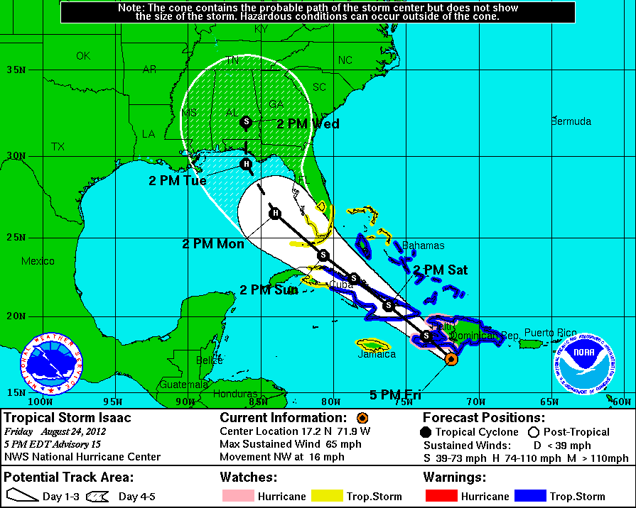
After several ragged days, Isaac looked more organized. At 5 p.m., forecasters at the National Hurricane Center said the storm’s winds had bumped up to 65 mph and it potentially could slam Haiti’s southwestern peninsula in the overnight hours as a Category 1 hurricane, dumping up to 20 inches of rain. They also put the Florida Keys, as well as most of coastal South Florida including Miami, under a tropical storm watch.
Isaac was expected to weaken again crossing much of the length of Cuba on Saturday and remain a tropical storm as it approaches the Keys on Sunday. But once in the warm Gulf of Mexico waters, Isaac could whip into a far more formidable concern next week as it bears down on the Panhandle and low-lying Alabama-Mississippi coastline.
In the Keys, administrators ordered schools and many government offices closed on Monday but emergency managers were waiting to see if the island chain would be placed under a hurricane watch before deciding whether to order tourists to pack up. No evacuation for Keys residents was planned. Miami-Dade also did not plan evacuations or closures.
Still, at least a few Keys visitors decided to beat any potential rush. At the Indian Key Fill boat ramp in Islamorada on Friday, friends Mike Rigby and Rusty Vasbinder loaded a 27-foot fishing boat onto a trailer.
“We’re deciding to cut our trip short a day because if they do decide to evacuate, we don’t want to get stuck in the bumper-to-bumper traffic,” said Terry Rigby of Cocoa Beach.
Though the threat of a direct impact to Miami-Dade and Broward counties appeared to have lessened, forecasters cautioned against taking Isaac lightly or its predicted path along the Gulf Coast as a sure thing.
One key model’s run pushed the core of the storm back toward mainland South Florida – and the latest track showed a slight shift to the east. Robbie Berg, an NHC hurricane specialist, called the shift “a little concerning’’ but also not unexpected. With Isaac still several days away, wobbles one way or another were likely, he said, but even a subtle change in steering currents can change the course of a storm.
“Trying to slice the baloney too thin can get you in trouble,” Berg said.
In Miami-Dade, Mayor Carlos Gimenez and emergency managers gathered at the Doral Emergency Operations Center to urge residents to prepare for a storm – but not one bad enough to cancel school, close offices or shut down services.
“We don’t anticipate this to be like Hurricane Andrew,” Gimenez said.
Still, on the 20th anniversary of Andrew, a Category 5 monster that devastated South Miami-Dade, at least some residents on Friday were taking no chances.
Across South Florida, supermarkets and hardware stores reported steady traffic on Friday, as residents prepared for Tropical Storm Isaac.
“We’ve been seeing a rush in our stores for your typical supplies,” said Winn-Dixie spokeswoman Mayra Hernandez, citing water, batteries, canned pastas and soups, juices, breads, chips, crackers and cookies among the biggest sellers. Stores in the Keys and South Miami-Dade have seen the heaviest crowds, she said.
“With the anniversary of Andrew people are just alarmed,” Hernandez said, “and it’s best to be prepared.”
But at Casey’s Corner Nursery in Homestead – ground zero for Andrew damage — it was business as usual. On Friday, owner Susan Casey was pulling plants for a local show.
“Honey, there’s no wind out here. There’s no rain out here,” she said. “I go by what I see outside and my feelings, and there’s nothing.”
The Florida Keys were expected to feel the worst of Isaac, with sustained winds of 35 to 50 mph and higher gusts from early Sunday through at least early Monday, said Adam Futterman, a meteorologist in the National Weather Service’s Key West office. Hurricane force gust were possible in some of Isaac’s most intense bands, he said.
“It’s going to be a day to stay inside,” he said. “Travel is strongly discouraged.’’
Miami-Dade and Broward were expected to see lots of squalls, with rain up to six inches in spots, along with winds up to 35 mph and stronger gusts to 50 or 55 mph from around Sunday morning to early Monday, according to the National Weather Service.
Gov. Rick Scott expressed concerns about impacts to the Keys and Panhandle but continued to hammer home a message Friday that the state is “open for business” and that the storm wasn’t an imminent threat to the Republican National Convention, which opens Monday in Tampa.
“There’ll be a little wind and a little rain,” he said with slight smile during a briefing. “But everyone will also see how nice people in Florida are.”
Read more here: http://www.miamiherald.com/2012/08/24/v-fullstory/2966208/isaac-remains-disorganized-heading.html#storylink=cpy
