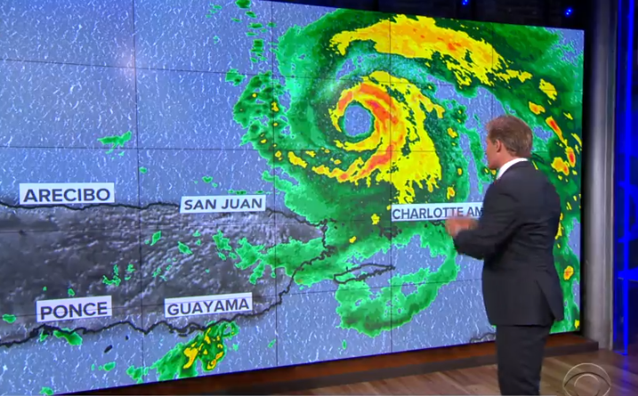
Dorian was upgraded to a hurricane Wednesday afternoon and was impacting Puerto Ricowith outer bands and the Virgin Islands with heavy rain and wind. The core of the storm’s worst weather is passing just east of Puerto Rico.
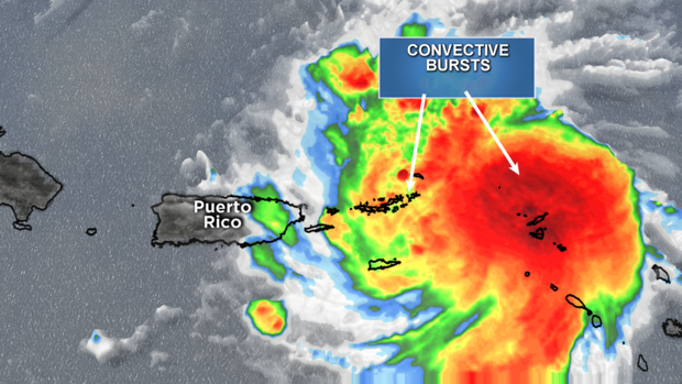
The reason the storm has shifted is because its circulation has been rather disorganized and big convective bursts (clusters of thunderstorms) on the east side of the circulation are making the system lopsided, pulling and tugging the center further east.
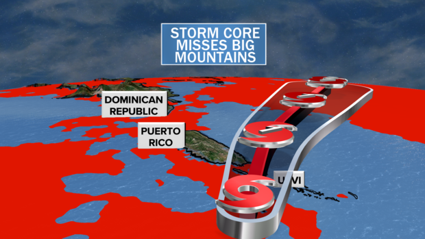
This means Dorian will avoid the beating it would have taken if the system had passed over the high mountains of Puerto Rico and the Dominican Republic. Instead, it will emerge north of the islands tonight as a healthy storm system. That healthy system can then more easily intensify as it moves north.
Knowing this, the next question is: Will the system enter an environment favorable for intensification? Increasingly, the answer seems to be yes.
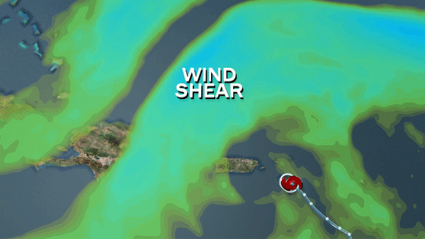
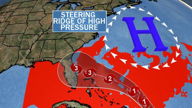
As you can see in the graphic below, the wind shear — meaning the hostile upper level winds — is strong to the north of Dorian. But in the coming days the wind shear will relax and an upper level high, or ridge, will develop to the north. This high will act like a cocoon, protecting Dorian from outside influence, allowing it to breathe.
The term “breathe” is meant in the literal sense; in order to get better organized, a system must pull warm, moist air into its center at the ocean surface and then exhaust that air outward at the top of the storm. In that way, the less restricted the breathing, the stronger the storm can get. Upper level ridges of high pressure provide this breathing room, and that is what will happen by the weekend.
The clockwise flow around the ridge of high pressure will also guide Dorian westward towards the Bahamas, reaching the islands by Saturday and Sunday. Throughout Dorian’s track from Friday to Monday, it will be moving over very warm water ranging from 85 to 90 degrees Fahrenheit. In order for a tropical system to strengthen, water temperatures must be 80 degrees or higher. Clearly these ocean temperatures are plenty warm enough.
Another important factor is Dorian’s small size. Smaller storms have a tendency for faster intensity shifts. And since they are smaller, they can more easily concentrate much of their energy near their core. Small systems, like Dorian, are perfect candidates for rapid intensification, especially when very warm water is waiting.
The hottest water temperatures will be encountered towards the end of Dorian’s journey as it passes through the fast-moving, narrow river of water called the Gulf Stream, which lies just offshore of the east coast of Florida. This will provide high-octane fuel for Dorian, likely giving the system a boost late this weekend into Monday.
All told, there is reason to believe this system will be a major hurricane, Category 3 or greater, when it reaches the southeast coast of the U.S. That is indeed what some of our computer models show.
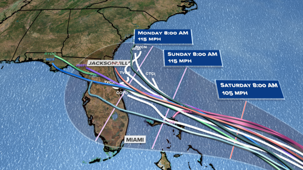
Now the big question remains, when and where will the storm make landfall? This is not a question that can be answered yet, as it is still days away — perhaps not nearing landfall until the Monday timeframe. The computer models present quite a wide range of possible tracks, with landfall possible from South Florida to the Carolina coast. But the concentration of the most reliable models narrow that range from Palm Beach, Florida, to Savannah, Georgia. That is still a wide net to cast.
So at this time anyone in the threat area should be freshening up their hurricane safety kitsand watching for forecast updates. There’s still some time and you can bet that Dorian will continue to throw curve balls along the way, but odds are Dorian will be powerful when it hits.